
A Brief History
East India Company and before
How I wish that somewhere there existed an island for those who are wise and of good will.{c}
⏱ QUICK READ
We present the highlights of what happened on St Helena in its -year recorded history. This is part one - up until the takeover by The Crown in 1834; learn about our earlier history on this page. Part two can be found on the page A Brief History (continued).

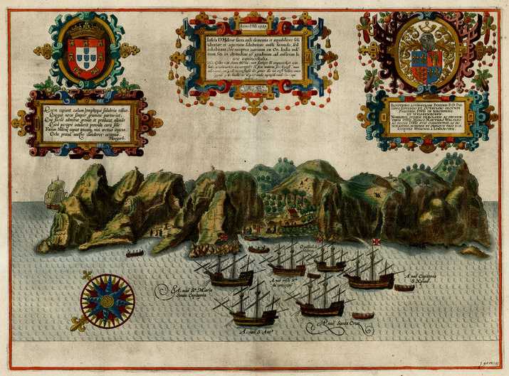
Wright’s map of St Helena, 1598
St Helena is Britain’s second oldest colony (after Bermuda). There are quite a few places in the world called St Helena (or some variation thereof), but our island has the distinction of being the original! Our St Helena was discovered and named in 1502. The places in America and Australia now called St Helena were all not named such until the 19th Century, at least 300 years after we were given the name…
If this history isn’t brief enough for you, we have an even briefer one!
Before Settlement
Below: Pre-Discovery Discovery Early History
Pre-Discovery
For information about the formation of St Helena see our page Geology of St Helena. For the human history prior to our discovery see our page Before Discovery.
Discovery
The facts of our island’s discovery are in dispute…

da Nova
stamp{d}
Most historical accounts state that the island was discovered on 21st May 1502 by the Galician navigator João da Nova (sometimes, incorrectly, written ‘João da Nova Castella’), sailing in the service of the King of Portugal. Anchoring in what is now James Bay, it is said that he named it ‘Santa Helena’ after St Helena of Constantinople, whose Saint’s Day falls on 21st May. However, there are a number of problems with this story. For a start, da Nova would have been a Catholic, and they celebrate St Helena’s Saints Day on 18th August, not 21st May. Protestants celebrate Saint Helena on 21st May, but they hadn’t even been invented in 1502…
Some have disputed that da Nova actually discovered it, but a relatively contemporary record has recently been found - by Luis de Figuerido Falcão, Secretary of the Portuguese Government - confirming that it was indeed da Nova that discovered St Helena. Unfortunately, Falcão, does not give a date for the discovery and various theories exist. Please read our page Discovery of St Helena to learn more. (For the record, we believe the most probable date for St Helena’s discovery is actually 3rd May 1502.)
Despite this, the official history taught on St Helena and generally accepted on the island is that St Helena was discovered by João da Nova on 21st May 1502 and named St Helena, and hence we celebrate our National Day every year on 21st May and celebrated our Quincentenary on 21st May 2002.
Any place that celebrates its discovery on a date when it wasn’t discovered has got to be worth further investigation…{e}
Discovery Titbits
Early History
You can read a more detailed account of this period on our page The Early Years.

The Portuguese tried to keep the discovery of St Helena a secret, but they failed. They found the island to have an abundance of trees and fresh water and deposited livestock (pigs, dogs, goats, cats and - inevitably - rats), fruit trees, and vegetables for the use of passing ships, thereby initiating the destruction of the island’s rare endemic species. They built a chapel and one or two houses, but initially formed no permanent settlement. They took to leaving sailors suffering from Scurvy and other ailments on the island, to fend for themselves and be taken home if they recovered by a subsequent ship. The island thereby became crucially important for the collection of food and water and as a rendezvous point for homebound voyages from Asia.

Somewhere between 1513 and 1516, one Fernão Lopez chose to be abandoned here, thus becoming the first exile on St Helena and also the first inhabitant. It is sometimes reported that, after Lopez, an un-named Franciscan friar occupied the island alone for fourteen years, until his death or possibly his removal by the Portuguese.
Sometime before 1557 five enslaved people escaped from a ship and remained hidden on the island for many years; long enough for their numbers to rise to twenty.
Linschoten print, 1596
Robin Castell claimed that Sir Francis Drake located the island on the final lap of his circumnavigation of the world (1577-1580), and thus the island became known to the English. The first Englishman to actually document the existence of St Helena was William Barret in the early 1580s, describing the island as fruitful of all things which a man can imagine, but it is not thought that he actually visited, getting his information from contemporary Portuguese navigators. On 25th September 1582 Englishman Edward Fenton set out a plan to occupy St Helena, become its king and live by waylaying returning Dutch East Indiamen, but he never attempted to enact his plan.
In 1588 Thomas Cavendish became the first Englishman actually to visit, arriving on 8th June during his first attempt to circumnavigate the world. He stayed for 12 days and described Chapel Valley as:
A marvellous fair and pleasant valley, wherein divers handsome buildings and houses were set up, and especially one which was a church, which was tiled, and whitened on the outside very fair, and made with a porch, and within the church at the upper end was set an alter. This valley is the fairest and largest low plot in all the island, and it is marvellous sweet and pleasant, and planted in every place with fruit trees or with herbs. There are on this island thousands of goats, which the Spaniards call cabritos, which are very wild: you shall sometimes see one or two hundred of them together, and sometimes you may behold them going in a flock almost a mile long.{4}

Portuguese map from 1601{5}
Once St Helena’s location was more widely known, English ships of war began to lie in wait in the area to attack Portuguese ships calling here. As a result, in 1592 the Portuguese ordered the annual fleet returning from Goa on no account to touch at St Helena. In developing their Far East trade, the Dutch also began to frequent the island. One of their first visits was in 1598 when an expedition of two vessels attacked a large Spanish Caravel{6}, only to be beaten off and forced to retreat to Ascension Island for repairs. The Portuguese soon gave up regularly calling at the island because of the attacks on their shipping, but also because of desecration to their chapel and images, destruction of their livestock and destruction of plantations by Dutch and English sailors.
On 16th June 1603 Sir James Lancaster visited St Helena on his return from his first voyage equipped by The East India Company, and by 1610 most English and Dutch ships visited the island on their home voyage to collect food and water{7}.
The ship James under captain John Hatch collected 4,000 lemons from the island in June 1621. According to one account a battle was fought in 1625 between the English, Dutch and Portuguese for possession of the island (the Portuguese won).

The Dutch Republic formally made claim to St Helena in 1633, although there is no evidence that they ever occupied, colonised or fortified it, thus rendering their claim invalid (according to the international laws of that time). By 1651, the Dutch had all but abandoned ideas of occupying the island, giving preference instead to their colony at the Cape of Good Hope.
It is said that as early as 1644 Richard Boothby, a stockholder of The East India Company, floated the idea of a colony on St Helena, having himself passed a Merry Christmas on the island, recommending it as pleasant, healthfull, frutifull, and commodious, perfect for trading with all Nations and naturally invincible and impregnable{26}. In 1649 The East India Company ordered all homeward-bound vessels to wait for one another at St Helena, and from 1656, because of many attacks on its ships the Company petitioned the government to send a man-of-war each year to convoy the fleet home from there.
The English take over

Having been granted in October 1657 Patents by the Lord Protector of the Commonwealth Oliver Cromwell, including rights to govern St Helena, in December 1658 the Company decided to fortify and colonise St Helena with Planters. Captain John Dutton, unable to enact his assignment to colonise Pollerone (Indonesia) due to war, was chosen for the task.

Church Valley in 1658 by Johan Nieuhof
A fleet commanded by Captain Dutton arrived at St Helena on 5th May 1659 and took control of the island, Dutton becoming the first Governor, from 1659-1661.
The party included a number of enslaved. A fort, originally named the Fort of St. John, was completed within a month and further houses were built further up the valley.
It soon became obvious that the island could not be made self-sufficient and in early 1658 The East India Company ordered all homecoming ships to provide one ton of rice on their arrival at the island.
With the restoration of the monarchy in 1660, the fort was renamed James Fort, the town Jamestown and the valley James Valley, all in honour of the Duke of York, later James II of England. The East India Company immediately sought a Royal Charter{10}, which was issued in April 1661 and gave the Company the sole right to fortify and colonise the island in such legal and reasonable manner the said Governor and Company should see fit.
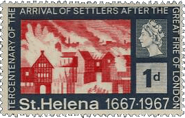
Every effort was made to induce persons in England to settle here. Advertisements were posted in the City of London and shiploads of young women were sent out, to remain a year unless otherwise disposed of{11}. Each Planter was allocated one of 130 pieces of land, and it is accepted history that additional settlers were brought here after the Great Fire of London in 1666{12}. But the Company had great difficulty attracting new immigrants, the population falling to only 66, including 18 enslaved, by 1670.
In 1671 The East India Company assigned the island its first Chaplain, William Noakes. If their aim was to calm the population, it failed: unrest began soon after and in 1672 then-Governor Coney was seized by rebellious members of the island’s council (including Noakes) and shipped back to England. Possibly as a result The East India Company issued some Laws for the conduct of the inhabitants.
The Dutch Invasion
Finding that the Cape of Good Hope was not the ideal harbour they originally envisaged, the Dutch East India Company (VoC) launched an armed invasion of St Helena over Christmas 1672. Four Dutch ships arrived off St Helena from the Cape carrying 180 soldiers and 150 sailors. A landing party came ashore at Lemon Valley but was repelled by English Planters hurling rocks from above. However, a discontented settler named William Coxe led the Dutch to a more remote and safer landing place in Swanley Valley. From there the Dutch made their way to High Peak and then Jamestown. Governor Beale was forced to abandon the island in a Company ship, sailing to Brazil where he located a flotilla of The East India Company and sent it to reinforce St Helena with fresh troops. The Company retook the island in May 1673 without loss of life and reinforced it with 250 troops.
You can read a more detailed account of this period on our page Invasion!.
The East India Company…again

{f}
In 1673 the Company obtained a new Charter from King Charles II which granted the island to The East India Company with free title as though it was a part of England in the same manner as East Greenwich in the County of Kent (You can read a modern-English version of the CharterⒾ{g}). Acknowledging that St Helena was a place where there was no trade, the Company was permitted to send from England any provisions free of Customs and to convey as many settlers as required.
Two ships, the European and the John & Alexander, set sail from England in December 1673, bound for St Helena with the aim of increasing the island population but discontent continued and in 1674 settlers and troops seized Governor Keigwin; it was only the lucky arrival of a fleet of The East India Company that freed him.
Shortly thereafter it was made a requirement for all ships trading with Madagascar to deliver one slave to St Helena. enslaved people were also brought from Asia by incoming shipping. Thus, most of the island’s enslaved came from Madagascar and Asia rather than the African mainland. By 1679, the number of enslaved had risen to about 80.
Another mutiny occurred in 1684, the ‘Dennison Mutiny’, after which one rebel, Gabriel Powell, grandfather of George Gabriel Powell, avoided hanging by becoming the island’s first (recorded) escapee. Rumours of an impending uprising by the enslaved in 1694 led to the gruesome execution of three of the enslaved and cruel punishment of many others. Ghost stories still told on the island relate to these executions.

French map of Jamestown, 1690s{1}
A Prospect of James Fort on the Island of St Helena. London, John Thornton, c1700{2}
The Island of St Helena, belonging to The East India Company of England, Jan Van Ryne, 1754
In September 1680 women were forbidden to board visiting ships except in daylight and in the company of their husbands, this measure presumably designed to control prostitution, and in 1684 The East India Company directed that St Helena’s principal highwayes be broadened to a width of 20 feet so that you may have large roads for droves of Cattel or loaden Oxen to meet upon with Conveniency as well as men (more about the origins of Jamestown’s roads on our page Roads). The clearance of the indigenous forest for the distillation of spirits, tanning and agricultural development began to lead to shortage of wood by the 1680s. In January 1690 several French Protestants, fleeing persecution at home, arrived and started a wine industry at Horse Pasture, but the attempt failed. One of their number, Stephen Poirier, later became Governor Poirier.
Following an edict issued by Governor Joshua Johnston that ships could not leave the port at night, to prevent escape attempts by members of the garrison, in April 1693 a soldier, Lieutenant Jackson led another mutiny, during which Governor Johnson was shot and fatally wounded.

Thornton’s map of 1703
The numbers of rats and wild goats had reached plague proportions by the 1690s, leading to the destruction of food crops and young tree shoots. In 1694 it is recorded that the rats after destroying everything else, fell to destroying each other The wild goat population increased so much that cattle could not survive on the remaining grazing so from October 1698 hunting parties were organised every Wednesday to shoot wild goats. Neither an increase on duty on the locally produced Arrack nor a duty on all firewood helped reduce the deforestation whilst attempts to reforest the island by Governor Roberts from 1708-1711 were not followed up by his immediate successors. The Great Wood, which once extended from Deadwood Plain to Prosperous Bay Plain, was reported in 1710 as not having a single tree left standing.
In February 1708 a soldier, Captain Mashborne, reported that he had found small amounts of gold among the limestone dug from Breakneck Valley after it was fired in a kiln. For a short period almost every able-bodied man was employed in prospecting for these precious metals. But the Breakneck Valley Gold Rush was short-lived; it ended with the results of an assay of the deposits in London, showing that they were simply iron pyrites (‘fool’s gold’).
In 1710 the settlers were optimistic on the future prosperity of the island:
Upon which we are now resolved to fire nine guns; to drink our honourable Master’s good health, and success to the Island; for we are well satisfied this Island will turn to account, and not be a dead charge, as it ever has been, if our honourable Masters will be pleased to encourage it, and supply these people with necessarys; and then there will be no aversion against improvements, but showers of blessings of these people will come to them.{h}{i}

Jamestown in 1781 by Lafitte{j}
English frigate at anchor off the island of St Helena, with a view of Jamestown, Thomas Luny 1788{3}
Jamestown in 1794
Despite the above, in 1715 Governor Pyke made the serious suggestion to the Company that appreciable savings could be made by moving the entire population to Mauritius. However, with the outbreak of war with other European countries, the Company continued to subsidise the island because of its strategic location. From 1715-1815 over 100 people attempted to escape from St Helena.
Rats were still a serious problem in the early 18th Century, and the cats released to control them became a problem in themselves. A visitor in 1717 commented that the vast number of wild cats preferred to live off young partridges rather than the rats. Rats were observed in 1731 building nests two feet across in trees, and an outbreak of plague in 1743 was attributed to the release of infected rats from ships arriving from India. By 1757 soldiers were being employed in killing the wild cats, which doubtless did nothing to reduce the rat problem.
A census in 1723 showed that the total population had risen to 1,110, 610 of which were enslaved. A severe drought between 1720 and 1724 nearly reduced the island to destitution, saved by heavy August rains in 1724. Meanwhile between 1723 and 1727 a wall was build around the Great Wood, in an unsuccessful attempt to preserve it.
An Ordinance was passed in 1731 to preserve the woodlands through the reduction in the goat population, but despite the clear connection between deforestation and the increasing number of floods, The East India Company’s Court of Directors gave little support to efforts by governors to eradicate the goat problem. In 1733 Green Tipped Bourbon Coffee seeds were brought from the coffee port of Mocha in Yemen, and were planted at various locations around the Island, the plants flourishing despite general neglect. In 1741 Captain Robert Jenkins was sent from England to St Helena to investigate charges of corruption brought against the acting governor, and from May 1741 until March 1742 he served as Governor. The island’s first hospital was built in 1742, on approximately the same site as the current General Hospital.
George Gabriel Powell became acting-Governor in July 1742, having won the approval of the directors of The East India Company by exposing fraud on the island. But according to accounts from the time, once he reached this position he began perpetrating much larger frauds himself. He may or may not have been guilty - his fraud-exposing days created him many enemies and it is possible the charges against him were fabricated. He left the island in 1748.
The 1750s were a very ‘wet decade’ with many incidents of trouble with rain or the sea (and also an Earthquake on 7th June 1756).
The first Parish Church in Jamestown had been showing signs of decay for many years, and in 1774 a new building was erected. St. James’ Church is now the oldest Anglican church south of the Equator and still retains many of its original features.
An order by Governor Corneill in 1783, banning garrison troops and sailors from punch-taverns and only allowing them to drink at army canteens, led to a mutiny over Christmas 1783 when some 200 troops occupied Alarm House before being defeated in battle. Their subsequent fate is told in the Mutineers of Alarm House ghost story.
{13}
The following diagram illustrates the frequency with which British ships called at St Helena from 1750 to 1800:
The importation of the enslaved was made illegal in 1792{14}. A March 1802 census counts 893 military personnel, 122 families and civil servants, 241 Planters, 227 formerly-enslaved and 1,029 enslaved; a total population of 2,511.
In 1806 Governor Patton recommended the Company import Chinese labourers to grow the rural workforce. The first Chinese labourers, from Canton, arrived in 1810, and the total number rose to about 650 by 1817{15}. In 1811 Governor Beatson banned soldiers from using the many inns and taverns and restricted them to drinking in the army canteen. The result was another rebellion, though this time it was settled with only minimal loss of life. Unlike the ‘Arrack Rebellion’ of 1783, this time the new regulations survived, with the effect that the 132 soldiers sick in the hospital were reduced within four months to 48. The Public Library was opened on 11th October 1813 for the dissemination of information and mass enlightenment of the people{16}. A census in 1814 showed the number of inhabitants was 3,507.
Napoleon Bonaparte…and after

James Fort, Town and Church from Read’s map of St Helena, 1817Ⓘ

Sir Hudson Lowe

In 1815 the British government selected St Helena as the place of detention for Napoleon{17}. He was brought to the island in October 1815 and lodged at Longwood House, where he lived until his death on 5th May 1821. During this period the island was strongly garrisoned by regular British regimental troops and by the local St Helena Regiment, with naval shipping circling the island. Agreement was reached that St Helena would remain in The East India Company’s possession, with the British government meeting additional costs arising from guarding Napoleon. Governor Lowe, was appointed by and directly reported to the Secretary for War and the Colonies, in London.
Brisk business was enjoyed catering for the additional 2,000 troops and personnel on the island over the six-year period, although restrictions placed against ships landing during this period posed a challenge for local traders to import the necessary goods. The 1817 census recorded 821 white inhabitants, a garrison of 820 men, 618 indentured Chinese labourers, 500 ‘free blacks’ and 1,540 enslaved. The same year an earthquake was felt on the island that shook houses and caused church bells to ring.
In 1818 Governor Lowe initiated the first step in emancipating the enslaved by persuading owners to give all enslaved children born after Christmas of that year their freedom once they had reached their late teens. The same year a religious feud broke out amongst the Chinese workers and the Garrison had to intervene to prevent loss of life, though the following year one of the Chinese was hanged for a possibly unrelated murder.
In January 1821 a ‘Review’ was held on Deadwood Plain to mark the 1st anniversary of King George IV’s accession{18}:
After Napoleon’s death the thousands of soldiers and other temporary visitors were soon withdrawn. The East India Company resumed full control of St Helena and life returned to the pre-1815 standards, the fall in population causing a sharp decline in the economy. Following praise of St Helena’s coffee given by Napoleon during his exile on the island, the product enjoyed a brief popularity in Paris during the years after his death.
The phased emancipation of the over 800 resident enslaved began in 1827, some six years before legislation to ban slavery in the colonies was passed by the British Parliament. Also in 1827 the Jamestown Prison was completed - it is still in use today, the building largely unaltered{19}. A plan set out in February 1828 to cover over part of The Run meets opposition - it is said the danger of flooding would increase.
Mynah Birds were introduced to the island in 1829, being seen as much in estimation as a destroyer of insects - today they are seen by many as a pest themselves.
An abortive attempt was made to set up a whaling company in 1837; investors declined to participate (wisely, it turned out!)
Later…
Our history continues on our page A Brief History (continued).
Read More
Below: Elsewhere on this site… Visit Our Museum Article: A Descriptive Sketch of The Island of St Helena
Elsewhere on this site…
A number of pages on this site deal with aspects of St Helena’s history, in more detail than is covered above. These are indexed on our page Island History.
To learn more about the people behind our island’s histories, and download some of the documents mentioned, see our page Historians of St Helena.
Over the years St Helena has hosted a number of important visitors, some of which are mentioned briefly above. You can learn more about them on our page Famous Visitors. Then there are those who came here against their will…, also mentioned briefly above. Learn more about them on our page Exiles.
Visit Our Museum
The Museum of St Helena is in Jamestown, at the foot of Jacob’s Ladder as you walk through to the Grand Parade. The Museum is run by the St Helena Heritage Society. For more information see our Community page, Museum of St Helena.
Article: A Descriptive Sketch of The Island of St Helena
By J. and E. Wallis, published 8th August 1815

THIS Island is situated in 15deg. 55min. south latitude, and 5deg. 49min. west longitude, from Greenwich{25}. Its length is ten miles and a half; breadth, six miles and three quarters; and its circumference about twenty-eight miles. It lies within the limit of the south-east Trade Winds, and is distant four hundred leagues from the coast of Africa, six hundred from that of South America, and twelve hundred from Cape St. Vincent in Portugal, the nearest point of Europe. The voyage from this country is usually performed in ten weeks.
It consists of one vast rock, perpendicular on every side, like a castle, in the middle of the Ocean, whose natural walls are too high to be attempted by scaling ladders; nor is there the smallest beach except at the Bay, called Chapel Valley Bay, which is fortified with a strong battery of large cannon planted even with the water, and farther defended by the perpetual dashing of prodigious waves against the shore, which, without further resistance, makes the landing difficult.
On rounding what is called Mundens Point, the eye is suddenly relieved by a view of James-town, seated in a narrow valley between two lofty mountains; and the interspersion of trees among the white houses, has an effect picturesque and pleasing in a high degree. This valley, known by the name of James Valley, is on the N. W. and leeward side of the Island, in which situation there is a good anchorage from eight to twenty-five fathoms; and fresh water is conveyed in leaden pipes to The Wharf from a spring two miles distant, which affords a plentiful supply. The surf, at times, is tremendous, particularly about Christmas, and many lives were lost in approaching and leaving the shore, until a new wharf and landing place were constructed by Governor Brooke.
Upon landing and passing the drawbridge, the way leads between a line of heavy guns and a double row of trees, of a lively green, generally in full leaf. The town is entered by an arched gateway, under a rampart, or terrace, forming one side of a parade about one hundred feet square. On the left side are the Government House{21} and main guard-room; the former is enclosed with a wall, having the semblance of embrasures, and is called the Castle; it contains the Governor’s habitation, and the offices of government. The church, fronting the gateway, is a neat, and not inelegant edifice. The principal street commences between it and a palisade inclosing the Company’s garden it consists of twenty-eight houses, most of them neat and well constructed, and divides into two other streets; one on the east, leading to that side of the country; the other proceeding to the upper part of the valley, where are situated the barracks, the new garden, and the hospital. In this street are a number of shops, well stored with European and Indian commodities; but the houses in general are far inferior to those in the lower part of the town, where the principal inhabitants reside. The two hills, between which the town is situated, are Ruperts on the east, and Ladder Hill on the west. The roads by which access is gained into the interior, are formed on the sides of these hills, and the ascent is so easy and safe, that carts and oxen pass along without danger or difficulty. For the first mile or two, the traveller observes little else than nakedness and sterility, but his curiosity is soon gratified by the sudden prospect of verdure, woody heights, neat dwellings, and cultivated plantations.
The island is unequally divided by a lofty chain, or ridge of hills, running nearly east and west. From this chain alternate ridges and valleys branch off in various directions. Diana’s Peak, towards the east end of this chain, is the highest point of the island, and rises nearly two thousand seven hundred feet above the level of the sea. From the summit of this peak, no point intercepts the horizon; the whole island is beneath the scope of vision; the ridges and hollows diverging from the chain, are traced to the sea. Houses and plantations diversify the prospect, and the contrast of verdant and naked mountains, renders the scene at once novel, picturesque, and majestic.
Thunder, lightning, or storms, rarely disturb the serenity of this mild atmosphere. The rain is divided more after the manner of our temperate climates than of the tropical ones; every month has its share, but July, August, and September, seem to be the most stormy. The luxuriance of vegetation increases in proportion to distance and height from the sea; and upon the very summits of the interior hills, oxen are to be seen up to their knees in grass. Fruits, particularly vines, figs, oranges, and lemons, ripen best in the valleys near the sea. From a garden more interior, but finely watered and sheltered, of no greater extent than three acres of ground, twenty-four thousand dozen apples of a large size, were gathered in one season, besides peaches, guavas, grapes, and figs, in abundance. The hopes of the farmer are frequently disappointed in the cultivation of wheat, barley, and oats, either from drought, or from the depredation of rats, which are frequently so numerous, as to destroy the most promising crop. Potatoes, cabbages, peas, beans, and other vegetables, are raised in great plenty.
The breed of cattle and sheep on the island, is originally English; the beef is of an excellent quality; but in consequence of the great demand from the Company’s shipping for fresh provisions, a bullock is seldom allowed to attain the age of four years. Rabbits abound in some situations; pheasant and partridge are become numerous, since the Government has given them protection; and every garden is enlivened by the notes of the Canary bird.
Of fish, it has been computed that seventy-six species frequent the coast. Those most commonly taken and used are mackerel, albacore, cavalloes, jacks, congers, soldiers, old wives, and bulls-eyes; and of shell fish, long-legs and stumps; these two last resemble the lobster in taste and colour, and have the same kind of tail. Upon an average of five years, from 1801 to 1805 inclusive, one hundred and sixty-five ships touch annually at St Helena; and in war time, the long detention for convoy experienced by large fleets (the crews and passengers of which are frequently equal to the whole population of the island) occasions such an extra consumption of stock and refreshments, that the mere productions of the island itself could never be adequate to such exigencies, were it not supplied with ample quantities of salt meat from England and of rice from Bengal. These articles, as they are cheaper than fresh provisions, constitute the principal food of the inhabitants and garrison. Salt meat is issued to them from the Company’s stores under prime cost, and every other article, at only ten per cent. advance, including freight. Beef is sold at 6½d. per pound alive, having been raised to that price since 1808, and as it is principally destined for the King’s, or the Company’s shipping, no person can kill even his own ox without permission from the Governor, a rule which has existed since the year 1752.
By the registered returns of the year 1805, the population of the island is stated at five hundred and four white inhabitants, one thousand five hundred and sixty blacks, of whom three hundred and twenty-nine were free; making a total of two thousand and sixty-four, exclusive of the garrison and civil establishment of the Company.
The island comprises only one parish; but, for the more regular performance of the county and parish officers’ duties, it is divided into three districts, viz. the east, the west, and the south, or Sandy Bay division. There are two churches, one in the town, and another in the country. Strangers, whilst they, remain at the island, are accommodated in private houses, at the rate off one guinea per day each, for which an excellent table, good wines, and comfortable lodgings, are provided.
By repeated charters from the Crown of Great Britain, the possession of St Helena is assigned in perpetual property to the East India Company, as Lords Proprietors, with powers of sovereignty and legislation. The supreme and executive authority within the island, is vested in the Governor, and a Council composed of the Lieutenant Governor, and senior civil servant, but sometimes a fourth member is added, as the Court of Directors judge proper. They are the representatives of the Lords Proprietors, and the superintending agents of all their concerns at the island. They are also Justices of the Peace, and Commissioners of Oyer and Terminer and Gaol Delivery, and they exercise the jurisdiction of the Ecclesiastical Court, in granting letters of administration, and proving wills, &c.
The Governor is exclusively entrusted with the powers of the Secret Committee of the Court of Directors. When the Council are not assembled, the authority of the whole Board concentrates in him; and, by charter from the Crown, when there is occasion, he may exercise the powers of captain-general. He is allowed a town and country residence, and a liberal table at the Company’s expense, with servants, horses, &c. The Lieutenant-Governor has likewise the privilege of a town and country house, some land, servants, and a few horses. The other member or members of Council are each allowed a town residence there are houses also for the engineer, chaplain, and head surgeon.
The military force of the island in 1808, was composed of a corps of artillery, commanded by a lieutenant-colonel, a regiment of infantry, and five companies of white and black militia, who were on the footing of volunteers; but this force has been lately augmented by forty of the royal artillery, commanded by a captain and two lieutenants, and the 53rd regiment of foot, five hundred strong.
The civil establishment consists of an accountant, paymaster, storekeeper, and the Secretary to Government, with their assistants.
St Helena is gifted with considerable attractions and advantages, both local and natural : the temperature and salubrity of the climate are not exceeded in any part of the world; the variations of heat and cold are moderate, and generally fluctuate near the point most congenial to animal existence; it is fanned by a constant and equable wind, surrounded by plenty and variety of fish, and refreshed by numerous springs of excellent water; the seclusion of its inhabitants is relieved by the frequent arrival of visitants and this intercourse chequers and corrects their uniformity of life, and tends to improve both the manners and the mind. The climate seems to be peculiarly adapted to the constitution of Europeans, of whom many have resided here for a long series of years, without suffering any malady.
The only endemic disorders to which the natives are subject, are of the catarrhal kind : these, as they belong to the inflammatory class, may in some measure account (notwithstanding their general robust health) for the few instances among the islanders, of longevity.
The anchorage in the road is safe and sheltered; and though the vessels riding there sometimes drive to sea, this is owing rather to the steep declivity of the bank, than to the force or impression of the wind. The surf is occasionally high and dangerous; but the ocean beyond it is never ruffled by those hurricanes, which in other climates occasion so much distress. The approach from the south-east is smooth and commodious; and on departing for Europe, the ship glides away before a gentle and steady breeze.

Credits:
{a} Arthur Bowes Smyth, 18th May 1789{b} W. Innes Pocock, RN{c} Albert Einstein{d} St Helena, Ascension and Tristan da Cunha Philatelic Society (‘SHATPS’){e} Social Media User{22}{f} G H Bellasis, 1815{g} St Helena Virtual Library and Archive{h} Extract from the Proceedings of the Governor and Council of St Helena, 15th August 1710{9}{i} From ‘A Handbook and Gazetteer of the Island of St Helena’, by G. C. Kitching, 1947{j} UK National Archives MPH 1/251{9}{23}{24}{k} John Kerr
Footnotes:
{1} We have seen this map attributed to Bellin, 1764, but we cannot accept this attribution because the Lines were established in 1706 and the Castle was rebuilt in 1708 but neither of these is shown. If this map were drawn in 1764 it was around 60 years out-of-date. It has also been attributed to Bellin with a different date - 1704 - which seems more likely.{2} A higher resolution but monochrome version of this map exists.{3} Thought to be the first painting with an accurate description of the coastline of St Helena. Presented in January 2017 to the Museum of St Helena by Mr Edward Baldwin.{4} For his complete description see our page Famous Visitors.{5} Clearly based on the Linschoten print of 1596.{6} Spain was then in alliance with Portugal.{7} Why only on the home (northbound) voyage? Well, it’s because of the strong Trade Winds in the South-east Atlantic, as explained fully on our page Before Discovery.{8} The four ‘Wirebird’ publications should not be confused.{9} @@RepDis@@{10} Needed because the October 1657 Patents granted by Oliver Cromwell became invalid after the Monarchy was restored and all acts passed by Cromwell were annulled.{11} Which, we assume, meant married off…!{12} But this is disputed by Alexander Schulenburg, who believes no such voyage occurred. Read his article in The Wirebird Summer 1999.{13} We love the depiction of the houses on the hill behind The Castle. Imagine trying to eat soup!{14} Though the existing enslaved were not freed.{15} John Kerr’s 1819 painting of Plantation House shows two people in Chinese dress in the middle-foreground: [Image, right]

{k}
{16} According to Percy Teale it is the oldest Public Library in the Southern Hemisphere.{17} To learn more about the events marking the Bicentenary of Napoleon’s arrival on St Helena check out our page Napoleonic Bicentenary for details.{18} Note also the people in Chinese dress (lower right) - presumably some of The Chinese Labourers here in the early 19th Century.{19} Though it was re-furbished in 2019 following a critical report from the Equality and Human Rights Commission.{20} Location of Jamestown according to latest GPS data.{21} Note that the term ‘Government House’ was originally applied to the Castle, and later to Plantation House.{22} Posted on Social Media and used with the poster’s permission but they wish to remain anonymous.{23} Not to be confused with the St Helena Archives.{24} Download the full mapⒾ.{25} Actually at 15°55’24.3”S; 5°43’3.5”W{20}.{26} We say It is said that because, like so many ‘facts’ of St Helena history, this is disputed. If you want to know more you can read a more detailed article about himⒾ by Ian Bruce, originally published in ‘Wirebird’, the magazine of Friends of St Helena{8} #47, October 2018{9}.
@@FNCRRETADV@@